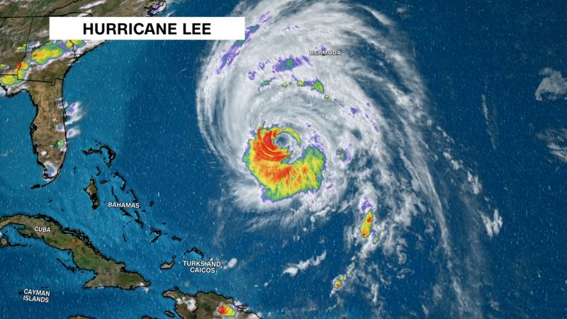
Hurricane Lee lashing Bermuda before striking coastal New England and Atlantic Canada
Hurricane Lee unleashed strong winds on Bermuda ahead of a track that will bring heavy rain, wind and coastal flooding to coastal New England and Atlantic Canada on Friday and through the weekend.
After days of uncertainty, there’s little time left for Lee’s track to change considerably, and confidence has grown now that the massive storm has completed its long-awaited northward turn and begun to pick up its pace.
Lee is expected to track far enough away from the East Coast to avoid delivering a substantial blow to a more widespread and inland area of New England, but will still affect the coast ahead of a weekend landfall somewhere between northeast Maine and the Canadian province of Nova Scotia.
Parts of the East Coast were already feeling the storm’s effects, including “dangerous surf and rip current conditions,” according to the National Hurricane Center.
Maine Gov. Janet Mills declared a state of emergency Thursday afternoon and requested federal assistance in preparation for Lee’s arrival.
Lee was about 210 miles west of Bermuda as of Thursday afternoon and was churning with maximum sustained winds of 85 mph – a Category 1 hurricane – according to the hurricane center. An island-wide tropical storm warning is in effect for Bermuda as Lee tracks west of the island.
Power outages mounted across Bermuda on Thursday afternoon as Lee’s winds battered the island, according to the island’s utility provider. Winds gusted up to 51 mph at Bermuda’s L.F. Wade International Airport.
Hurricane and tropical storm watches have been issued for many of New England’s coastal residents in anticipation of the colossal storm’s impact on Friday and through the weekend.
A tropical storm warning issued along New England’s coast was extended northward to the US and Canada border, the hurricane center said in a 5 p.m. advisory. And a tropical storm warning in effect for the coast of Massachusetts was extended westward to Westport, according to the advisory.
Though the storm is expected to weaken as it approaches land, it will still have a massive radius of damaging winds that could pound coastal New England and Canada’s Atlantic provinces. As of Thursday evening, hurricane-force winds extended up to 105 miles from its center and tropical storm-force winds stretched for up to 345 miles, according to the hurricane center.
Hurricane-strength winds are possible from the northern coast of Maine into portions of the Canadian provinces of New Brunswick and Nova Scotia on Saturday. Tropical storm-force wind gusts are possible across a much larger area of New England and Atlantic Canada.
These strong winds will contribute to storm surge flooding up to 3 feet that could inundate parts of the southeast Massachusetts coast late Friday and Saturday.
Heavy rainfall could pose a flood threat to some already rain-drenched areas of the Northeast, where saturated ground may be particularly susceptible to flash flooding. Lee’s heaviest rain will fall over portions of Maine Saturday, but states like New Hampshire, Massachusetts and Rhode Island are not completely in the clear.
Lee could deliver 1 to 2 inches of rain from Rhode Island to northern Maine, while 2 to 4 inches of rain can fall across the Massachusetts Cape and much of Maine. Repeated downpours may bring up to 6 inches of rain to southeastern Maine.
The softened soil combined with stiff wind gusts will also increase the likelihood of downed trees, which in turn could knock out essential power lines and cause outages. Areas at and near the coast, which will feel the strongest of Lee’s winds, will be the most at risk of wind damage and power outages.
