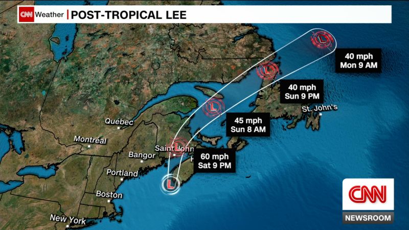
Post-tropical cyclone Lee makes landfall in Nova Scotia, forecast to bring strong wind gusts and rain as it moves inland
Now a post-tropical cyclone, Lee made landfall on the far western tip of Nova Scotia on Saturday afternoon as it churned 65 mph sustained winds to parts of southeastern New England and Atlantic Canada, according to the National Hurricane Center.
The storm made landfall on Long Island in Nova Scotia around 4 p.m. Atlantic Time (3 p.m. ET). It will move across the Bay of Fundy and move inland around Maine and the New Brunswick, Canadian border on Saturday evening.
Lee is forecast to weaken within hours after its landfall, but it will still be capable of heavy rains, coastal flooding and high winds as it tracks across the region overnight and early Sunday.
More than 200,000 residents across Maine and Canada’s New Brunswick and Nova Scotia are experiencing power outages. A tropical storm warning is in effect for some areas.
Utility power crews are in the field assessing damages and actively responding to downed utility lines and other damage caused by the storm.
States of emergency have been declared in Maine and Massachusetts. President Biden has authorized the Department of Homeland Security and the Federal Emergency Management Agency (FEMA) to step in to coordinate disaster relief and assistance for required emergency measures.
Lee had maximum sustained wind speeds of 70 mph, according to an update from the National Hurricane Center, which is equivalent to tropical storm-force winds.
Tropical storm-force winds currently extend outward over 300 miles.
An observation in Knox County, Maine, recently reported a wind gust of 63 mph.
In addition to ferocious winds, Lee was expected to unleash up to six inches of rain in far northern Maine on Saturday, with neighboring New Hampshire, Massachusetts and Rhode Island also at risk of seeing heavy precipitation.
As the New England coast feels the effects, Boston’s Logan International Airport saw a spike in flight cancellations Saturday morning. According to the flight tracking website FlightAware, 23% of all flights into Boston and 24% of flights originating out of the city have been canceled Saturday, for a total of more than 117 flight cancellations so far.
At the coast from the Long Island Sound north through Maine, flooding of 1 to 3 feet above ground level is possible if Lee’s storm surge coincides with high tide, according to National Hurricane Center director Michael Brennan.
Canada and US residents along shore urged to stay indoors
National Hurricane Center deputy director Jamie Rhome warned that people should avoid driving near shores and urged them to stay home to ride out the storm. He also noted there’s a high rip current risk extending from southern Florida stretching thousands of miles north to Maine.
“The waves from this big hurricane produce a current that goes out to sea and will pull you out,” Rhome said Friday evening in a brief video update. “So, if you’re going to go to the beach this weekend, swim near a lifeguard.”
In anticipation of those dangerous waves, local officials in Toms River, New Jersey, barred swimming this weekend at Ortley Beach, according to a news release from the township. Violators may be ticketed.
“Lifeguards will be on duty Saturday and Sunday from 9:00 a.m. to 5:00 p.m. to enforce the Red Flag ban on swimming. The beach itself will be open,” officials said in a news release Friday.
Meanwhile in Canada, officials in New Brunswick cautioned residents to prepare for power outages and stock up on food and medication for at least 72 hours as they encouraged people to stay indoors.
“Once the storm starts, remember please stay at home if at all possible,” said Kyle Leavitt, director of New Brunswick Emergency Measures Organization. “Nothing good can come from checking out the big waves and how strong the wind truly is. Not only are you putting yourself at risk, but you are putting at risk the lives of the emergency services personnel who may have to assist you.”
